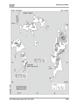
VAC chart of ROKR
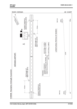
 ADC chart of ROKR
 Satellite view of ROKR
ADC chart of ROKR
Satellite view of ROKR
Sorry, we have no imagery here.
Sorry, we have no imagery here.
Sorry, we have no imagery here.
Sorry, we have no imagery here.
Sorry, we have no imagery here.
Sorry, we have no imagery here.


ROKR - Kerama
Located in , Japan
ICAO - ROKR, IATA - KJP
Data provided by AirmateGeneral information
Coordinates: N26°10'6" E127°17'36"
Elevation is 156 feet MSL.
View others Airports in Okinawa Prefecture
Operational data
Special qualification required
Current time UTC:
Current local time:
Weather at : ROAH - Naha ( 35 km )
METAR: ROAH 111000Z 21004KT CAVOK 22/18 Q1011 RMK A2988
TAF: TAF AMD ROAH 110657Z 1106/1212 22006KT 9999 FEW020 TEMPO 1118/1200 FEW003 BKN008 BECMG 1121/1200 17020KT TEMPO 1200/1209 17022G32KT
Communications frequencies: [VIEW]
Runways:
| RWY identifier | QFU | Length (ft) | Width (ft) | Surface | LDA (ft) |
| 02 | 0° | 2625 | 82 | UNK | |
| 20 | 0° | 2625 | 82 | UNK |
Airport contact information
Address: Japan
Satellite view of ROKR
Sorry, we have no imagery here.
Sorry, we have no imagery here.
Sorry, we have no imagery here.
Sorry, we have no imagery here.
Sorry, we have no imagery here.
Sorry, we have no imagery here.