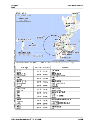
VAC chart of ROAH
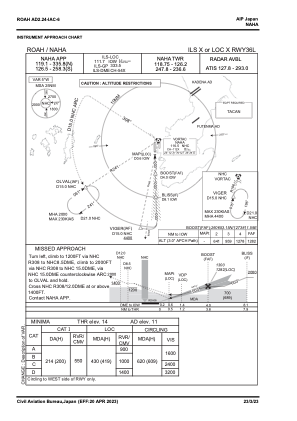
 IAC chart of ROAH
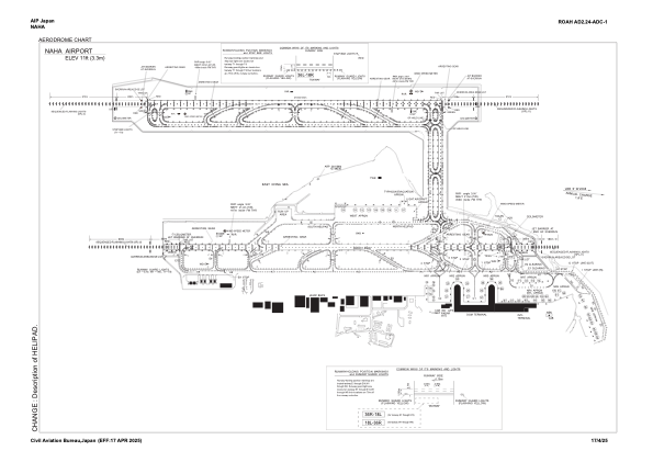
 ADC chart of ROAH
 Satellite view of ROAH
IAC chart of ROAHADC chart of ROAH
Satellite view of ROAH
Sorry, we have no imagery here.
Sorry, we have no imagery here.
Sorry, we have no imagery here.
Sorry, we have no imagery here.
Sorry, we have no imagery here.


ROAH - Naha
Located in Naha, Japan
ICAO - ROAH, IATA - OKA
Data provided by AirmateGeneral information
Coordinates: N26°11'36" E127°38'23"
Elevation is 11 feet MSL.
View others Airports in Okinawa Prefecture
Operational data
Special qualification required
Current time UTC:
Current local time:
Weather
METAR: ROAH 101730Z AUTO 03004KT 9999 SCT019 BKN023 BKN028 19/18 Q1009 RMK A2980
TAF: TAF ROAH 101708Z 1018/1200 02008KT 9999 FEW010 BKN020 BECMG 1106/1109 12006KT TEMPO 1112/1200 FEW003 BKN008 BECMG 1121/1200 16016KT
Communications frequencies: [VIEW]
Runways:
| RWY identifier | QFU | Length (ft) | Width (ft) | Surface | LDA (ft) |
| 18L | 177° | 9843 | 148 | UNK | |
| 36R | 357° | 9843 | 148 | UNK | |
| 18R | 177° | 8858 | 197 | UNK | |
| 36L | 357° | 8858 | 197 | UNK |
Airport contact information
Address: Naha Japan
Satellite view of ROAH
Sorry, we have no imagery here.
Sorry, we have no imagery here.
Sorry, we have no imagery here.
Sorry, we have no imagery here.
Sorry, we have no imagery here.