VAC chart of RKPD
 IAC chart of RKPD
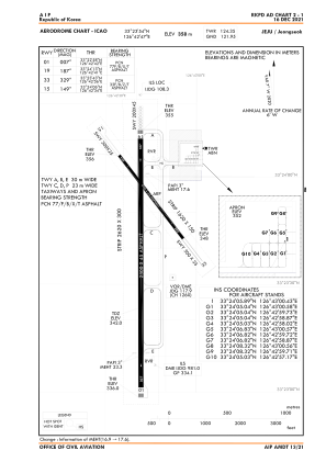
 ADC chart of RKPD
 Satellite view of RKPD

IAC chart of RKPDADC chart of RKPD
Satellite view of RKPD
Sorry, we have no imagery here.
Sorry, we have no imagery here.
Sorry, we have no imagery here.
Sorry, we have no imagery here.
Sorry, we have no imagery here.
Sorry, we have no imagery here.


RKPD - Jeju / Jeongseok
Located in Jeju, Korea, Republic of
ICAO - RKPD, IATA - JDG
Data provided by AirmateGeneral information
Coordinates: N33°23'54" E126°42'47"
Elevation is 1174 feet MSL.
View others Airports in Jejudo
Operational data
Special qualification required
Current time UTC:
Current local time:
Weather at : RKPC - Jeju / Jeju International ( 24 km )
METAR: RKPC 030200Z 08030KT 5000 -RA BR SCT007 BKN030 OVC070 08/06 Q1016 WS ALL RWY NOSIG
TAF: TAF RKPC 022300Z 0300/0406 08022G45KT 6000 -RA FEW010 BKN035 OVC080 TX10/0300Z TN07/0320Z TX10/0405Z TEMPO 0300/0303 08020G35KT 4000 -DZ FEW010 BKN025 OVC060 BECMG 0401/0403 06017G35KT
Communications frequencies: [VIEW]
Runways:
| RWY identifier | QFU | Length (ft) | Width (ft) | Surface | LDA (ft) |
| 01 | 360° | 7546 | 148 | ASP | |
| 19 | 180° | 7546 | 148 | ASP | |
| 15 | 142° | 2953 | 82 | ASP | |
| 33 | 322° | 2953 | 82 | ASP |
Airport contact information
Address: Jeju Korea, Republic of
Satellite view of RKPD
Sorry, we have no imagery here.
Sorry, we have no imagery here.
Sorry, we have no imagery here.
Sorry, we have no imagery here.
Sorry, we have no imagery here.
Sorry, we have no imagery here.