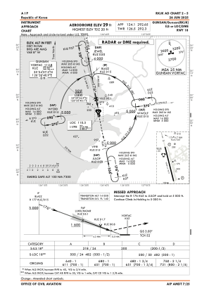
IAC chart of RKJK
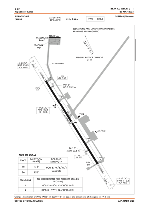
 ADC chart of RKJK
 Satellite view of RKJK
ADC chart of RKJK
Satellite view of RKJK
Sorry, we have no imagery here.
Sorry, we have no imagery here.
Sorry, we have no imagery here.
Sorry, we have no imagery here.
Sorry, we have no imagery here.
Sorry, we have no imagery here.


RKJK - Gunsan / Domestic
Located in Gunsan, Korea, Republic of
ICAO - RKJK, IATA - KUV
Data provided by AirmateGeneral information
Coordinates: N35°54'14" E126°36'57"
Elevation is 30 feet MSL.
Magnetic variation is -8° East View others Airports in Jeonrabugdo
Operational data
Special qualification required
Current time UTC:
Current local time:
Weather
METAR: RKJK 151855Z 15006KT 5SM BR FEW130 06/04 A2981 RMK AO2A SLPNO T00570039 $
TAF: TAF RKJK 151600Z 1516/1622 15007KT 6000 BR FEW200 QNH2977INS BECMG 1519/1520 19010G15KT 8000 BR FEW100 SCT200 510154 QNH2976INS BECMG 1603/1604 21015G25KT 9000 HZ FEW100 BKN180 510055 QNH2971INS BECMG 1613/1614 19012G20KT 9000 BR FEW005 SCT015 BKN080 510055 QNH2972INS BECMG 1617/1619 19012G22KT 8000 BR SCT005 BKN015 510055 QNH2970INS TX18/1606Z TN04/1521Z
Communications frequencies: [VIEW]
Runways:
| RWY identifier | QFU | Length (ft) | Width (ft) | Surface | LDA (ft) |
| 18 | 169° | 9009 | 150 | CON | |
| 36 | 349° | 9009 | 150 | CON |
Airport contact information
Address: Gunsan Korea, Republic of
Satellite view of RKJK
Sorry, we have no imagery here.
Sorry, we have no imagery here.
Sorry, we have no imagery here.
Sorry, we have no imagery here.
Sorry, we have no imagery here.
Sorry, we have no imagery here.