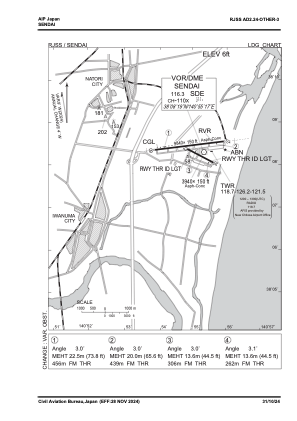
VAC chart of RJSS
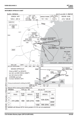
 IAC chart of RJSS
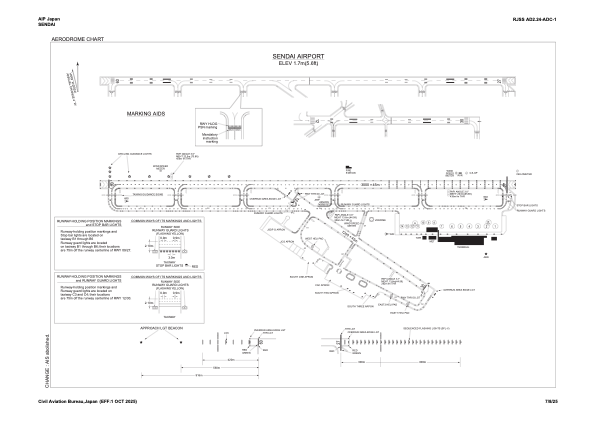
 ADC chart of RJSS
 Satellite view of RJSS
IAC chart of RJSSADC chart of RJSS
Satellite view of RJSS
Sorry, we have no imagery here.
Sorry, we have no imagery here.
Sorry, we have no imagery here.
Sorry, we have no imagery here.
Sorry, we have no imagery here.
Sorry, we have no imagery here.


RJSS - Sendai
Located in Sendai, Japan
ICAO - RJSS, IATA - SDJ
Data provided by AirmateGeneral information
Coordinates: N38°8'23" E140°55'1"
Elevation is 6 feet MSL.
View others Airports in Miyagi Prefecture
Operational data
Special qualification required
Current time UTC:
Current local time:
Weather
TAF: TAF RJSS 151705Z 1518/1700 27018KT 9999 FEW030 BKN050 TEMPO 1522/1615 27028G40KT BECMG 1618/1621 21006KT
Communications frequencies: [VIEW]
Runways:
| RWY identifier | QFU | Length (ft) | Width (ft) | Surface | LDA (ft) |
| 09 | 83° | 9843 | 148 | ASP | |
| 27 | 263° | 9843 | 148 | ASP | |
| 12 | 118° | 3937 | 148 | ASP | |
| 30 | 298° | 3937 | 148 | ASP |
Airport contact information
Address: Sendai Japan
Satellite view of RJSS
Sorry, we have no imagery here.
Sorry, we have no imagery here.
Sorry, we have no imagery here.
Sorry, we have no imagery here.
Sorry, we have no imagery here.
Sorry, we have no imagery here.