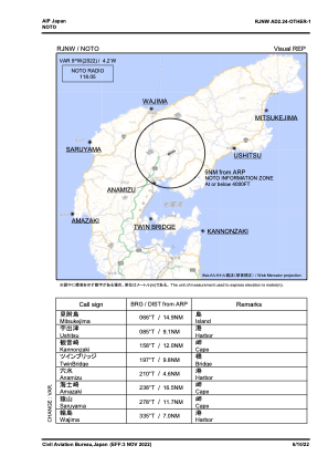
VAC chart of RJNW
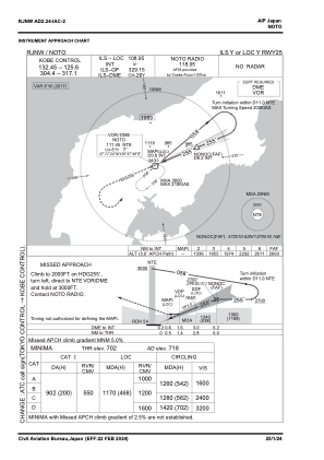
 IAC chart of RJNW
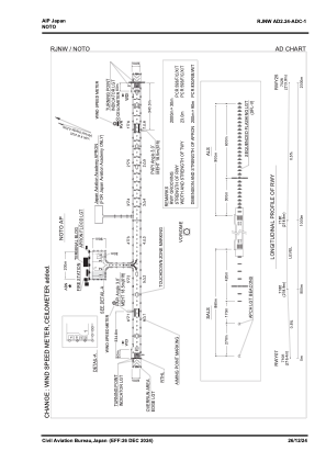
 ADC chart of RJNW
 Satellite view of RJNW
IAC chart of RJNWADC chart of RJNW
Satellite view of RJNW
Sorry, we have no imagery here.
Sorry, we have no imagery here.
Sorry, we have no imagery here.
Sorry, we have no imagery here.
Sorry, we have no imagery here.
Sorry, we have no imagery here.


RJNW - Noto
Located in Wajima, Japan
ICAO - RJNW, IATA - NTQ
Data provided by AirmateGeneral information
Coordinates: N37°17'36" E136°57'44"
Elevation is 718 feet MSL.
View others Airports in Ishikawa Prefecture
Operational data
Special qualification required
Current time UTC:
Current local time:
Weather
METAR: RJNW 120100Z 12005KT 060V210 9999 FEW015 BKN018 11/07 Q1016
Communications frequencies: [VIEW]
Runways:
| RWY identifier | QFU | Length (ft) | Width (ft) | Surface | LDA (ft) |
| 07 | 67° | 6562 | 148 | ASP | |
| 25 | 247° | 6562 | 148 | ASP |
Airport contact information
Address: Wajima Japan
Satellite view of RJNW
Sorry, we have no imagery here.
Sorry, we have no imagery here.
Sorry, we have no imagery here.
Sorry, we have no imagery here.
Sorry, we have no imagery here.
Sorry, we have no imagery here.