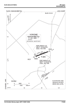
VAC chart of RJCN
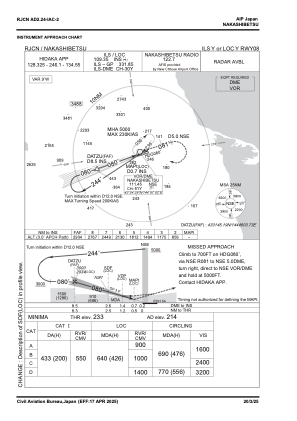
 IAC chart of RJCN
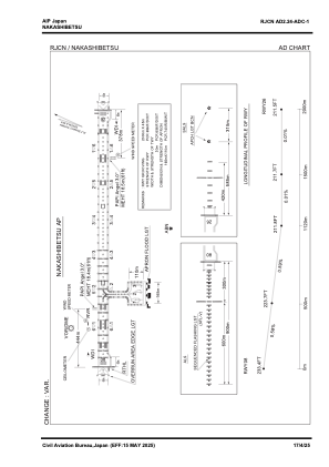
 ADC chart of RJCN
 Satellite view of RJCN
IAC chart of RJCNADC chart of RJCN
Satellite view of RJCN
Sorry, we have no imagery here.
Sorry, we have no imagery here.
Sorry, we have no imagery here.
Sorry, we have no imagery here.
Sorry, we have no imagery here.
Sorry, we have no imagery here.


RJCN - Nakashibetsu
Located in Nakashibetsu, Japan
ICAO - RJCN, IATA - SHB
Data provided by AirmateGeneral information
Coordinates: N43°34'39" E144°57'36"
Elevation is 214 feet MSL.
View others Airports in Hokkaido Prefecture
Operational data
Special qualification required
Current time UTC:
Current local time:
Communications frequencies: [VIEW]
Runways:
| RWY identifier | QFU | Length (ft) | Width (ft) | Surface | LDA (ft) |
| 08 | 71° | 6562 | 148 | ASP | |
| 26 | 251° | 6562 | 148 | ASP |
Airport contact information
Address: Nakashibetsu Japan
Satellite view of RJCN
Sorry, we have no imagery here.
Sorry, we have no imagery here.
Sorry, we have no imagery here.
Sorry, we have no imagery here.
Sorry, we have no imagery here.
Sorry, we have no imagery here.