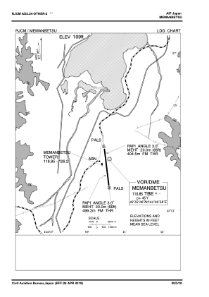
VAC chart of RJCM
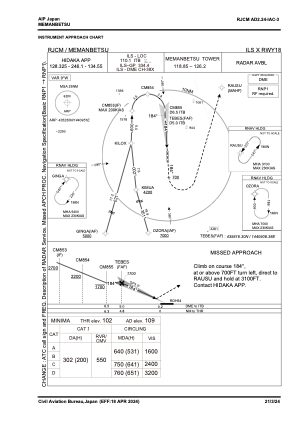
 IAC chart of RJCM
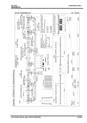
 ADC chart of RJCM
 Satellite view of RJCM
IAC chart of RJCMADC chart of RJCM
Satellite view of RJCM
Sorry, we have no imagery here.
Sorry, we have no imagery here.
Sorry, we have no imagery here.
Sorry, we have no imagery here.
Sorry, we have no imagery here.
Sorry, we have no imagery here.


RJCM - Memanbetsu
Located in Abashiri, Japan
ICAO - RJCM, IATA - MMB
Data provided by AirmateGeneral information
Coordinates: N43°52'50" E144°9'51"
Elevation is 109 feet MSL.
View others Airports in Hokkaido Prefecture
Operational data
Special qualification required
Current time UTC:
Current local time:
Weather
METAR: RJCM 160100Z 30006KT 220V360 9999 -SHRA FEW006 SCT010 BKN015 05/03 Q0980
TAF: TAF RJCM 152305Z 1600/1706 31010KT 9999 -SHRA FEW005 BKN015 TEMPO 1600/1606 3000 SHRA BR FEW002 BKN005 TEMPO 1612/1618 4000 -SHRA BR FEW005 BKN008
Communications frequencies: [VIEW]
Runways:
| RWY identifier | QFU | Length (ft) | Width (ft) | Surface | LDA (ft) |
| 18 | 175° | 8202 | 148 | ASP | |
| 36 | 355° | 8202 | 148 | ASP |
Airport contact information
Address: Abashiri Japan
Satellite view of RJCM
Sorry, we have no imagery here.
Sorry, we have no imagery here.
Sorry, we have no imagery here.
Sorry, we have no imagery here.
Sorry, we have no imagery here.
Sorry, we have no imagery here.