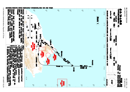
IAC chart of RCSS
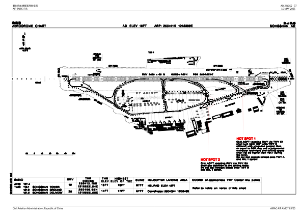
 ADC chart of RCSS
 Satellite view of RCSS
ADC chart of RCSS
Satellite view of RCSS
Sorry, we have no imagery here.
Sorry, we have no imagery here.
Sorry, we have no imagery here.
Sorry, we have no imagery here.
Sorry, we have no imagery here.
Sorry, we have no imagery here.


RCSS - Taipei/Songshan
Located in Taipei, Taiwan, Province of China
ICAO - RCSS, IATA - TSA
Data provided by AirmateGeneral information
Coordinates: N25°4'11" E121°33'9"
Elevation is 18 feet MSL.
View others Airports in Taipei (municipality)
Operational data
Special qualification required
Current time UTC:
Current local time:
Weather
METAR: RCSS 171700Z VRB02KT 9999 FEW020 SCT220 26/24 Q1011 NOSIG RMK A2986
TAF: TAF RCSS 171700Z 1718/1818 09005KT 9999 FEW020 TEMPO 1802/1806 30005KT TEMPO 1806/1810 10010KT 2500 TSRA FEW008 FEW012CB BKN015 BKN030 TEMPO 1810/1814 5000 RA FEW012 BKN022 BKN040
Communications frequencies: [VIEW]
Runways:
| RWY identifier | QFU | Length (ft) | Width (ft) | Surface | LDA (ft) |
| 10 | 92° | 8547 | 197 | ASP | |
| 28 | 272° | 8547 | 197 | ASP |
Airport contact information
Address: Taipei Taiwan, Province of China
Satellite view of RCSS
Sorry, we have no imagery here.
Sorry, we have no imagery here.
Sorry, we have no imagery here.
Sorry, we have no imagery here.
Sorry, we have no imagery here.
Sorry, we have no imagery here.