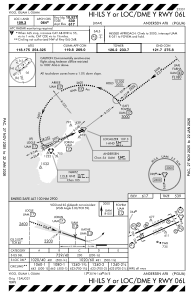
IAC chart of PGUA
 ADC chart of PGUA
 Satellite view of PGUA
ADC chart of PGUA
Satellite view of PGUA
Sorry, we have no imagery here.
Sorry, we have no imagery here.
Sorry, we have no imagery here.
Sorry, we have no imagery here.
Sorry, we have no imagery here.
Sorry, we have no imagery here.


PGUA - Andersen Afb
Located in Yigo, Guam
ICAO - UAM, IATA - UAM
Data provided by AirmateGeneral information
Coordinates: N13°35'2" E144°55'48"
Elevation is 617 feet MSL.
Magnetic variation is 02° East View others Airports in (unassigned)
Operational data
Special qualification required
Current time UTC:
Current local time:
Weather
METAR: PGUA 112310Z AUTO 10013KT 10SM OVC008 28/25 A2995 RMK AO2 SLP132 $
TAF: TAF AMD PGUA 112200Z 1122/1224 11010KT 9999 SCT015 QNH2984INS TEMPO 1122/1204 6000 SHRA BKN010 TX30/1202Z TN25/1122Z
Communications frequencies: [VIEW]
Runways:
| RWY identifier | QFU | Length (ft) | Width (ft) | Surface | LDA (ft) |
| 06L | 0° | 10528 | 200 | CONC+ASPH | |
| 24R | 0° | 10528 | 200 | CONC+ASPH | |
| 06R | 0° | 11200 | 200 | CONC+ASPH | |
| 24L | 0° | 11200 | 200 | CONC+ASPH |
Airport contact information
Address: Yigo Guam
Satellite view of PGUA
Sorry, we have no imagery here.
Sorry, we have no imagery here.
Sorry, we have no imagery here.
Sorry, we have no imagery here.
Sorry, we have no imagery here.
Sorry, we have no imagery here.