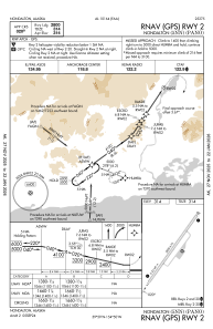
IAC chart of PANO
 Satellite view of PANO
Satellite view of PANO
Sorry, we have no imagery here.
Sorry, we have no imagery here.
Sorry, we have no imagery here.
Sorry, we have no imagery here.
Sorry, we have no imagery here.
Sorry, we have no imagery here.


PANO - Nondalton
Located in Nondalton,
ICAO - 5NN, IATA -
Data provided by AirmateGeneral information
Coordinates: N59°58'49" W154°50'21"
Elevation is 314 feet MSL.
Magnetic variation is 14° East View others Airports in Alaska
Operational data
Special qualification required
Current time UTC:
Current local time:
Weather at : PAIL - Iliamna ( 25 km )
METAR: PAIL 051353Z 00000KT 10SM 06/01 A2944 RMK AO2 RAB03E13 SLP969 P0000 T00560011 $
TAF: PAIL 051131Z 0512/0612 09010G20KT P6SM VCSH OVC035 FM051800 07006KT P6SM BKN045 FM060300 02006KT P6SM -RA OVC015 FM060600 02005KT 6SM -RA BR OVC007 AMD LTD TO WIND VIS AND WX TIL 051500
Communications frequencies: [VIEW]
Runways:
| RWY identifier | QFU | Length (ft) | Width (ft) | Surface | LDA (ft) |
| 02 | 38° | 2800 | 75 | GRAVEL | |
| 20 | 218° | 2800 | 75 | GRAVEL |
Airport contact information
Address: Nondalton
Satellite view of PANO
Sorry, we have no imagery here.
Sorry, we have no imagery here.
Sorry, we have no imagery here.
Sorry, we have no imagery here.
Sorry, we have no imagery here.
Sorry, we have no imagery here.