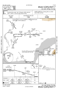
IAC chart of PAGQ
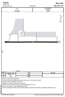
 ADC chart of PAGQ
 Satellite view of PAGQ
ADC chart of PAGQ
Satellite view of PAGQ
Sorry, we have no imagery here.
Sorry, we have no imagery here.
Sorry, we have no imagery here.
Sorry, we have no imagery here.
Sorry, we have no imagery here.
Sorry, we have no imagery here.


PAGQ - Big Lake
Located in Big Lake,
ICAO - BGQ, IATA - BGQ
Data provided by AirmateGeneral information
Coordinates: N61°32'5" W149°48'45"
Elevation is 162 feet MSL.
Magnetic variation is 15° East View others Airports in Alaska
Operational data
Special qualification required
Current time UTC:
Current local time:
Weather at : PAWS - Wasilla ( 15 km )
METAR: PAWS 050856Z AUTO 12007KT OVC090 08/00 A2960 RMK AO2 SLP025 T00780000 57001 PWINO RVRNO $
Communications frequencies: [VIEW]
Runways:
| RWY identifier | QFU | Length (ft) | Width (ft) | Surface | LDA (ft) |
| 07 | 90° | 2450 | 70 | GRAVEL | |
| 25 | 270° | 2450 | 70 | GRAVEL |
Airport contact information
Address: Big Lake
Satellite view of PAGQ
Sorry, we have no imagery here.
Sorry, we have no imagery here.
Sorry, we have no imagery here.
Sorry, we have no imagery here.
Sorry, we have no imagery here.
Sorry, we have no imagery here.