IAC chart of PAFR
 ADC chart of PAFR
 Satellite view of PAFR
ADC chart of PAFR
Satellite view of PAFR
Sorry, we have no imagery here.
Sorry, we have no imagery here.
Sorry, we have no imagery here.
Sorry, we have no imagery here.
Sorry, we have no imagery here.
Sorry, we have no imagery here.


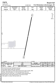
PAFR - Bryant Aaf
Located in Fort Richardson (Anchorage),
ICAO - FRN, IATA - FRN
Data provided by AirmateGeneral information
Coordinates: N61°15'57" W149°39'12"
Elevation is 387 feet MSL.
Magnetic variation is 15° East View others Airports in Alaska
Operational data
Special qualification required
Current time UTC:
Current local time:
Weather
METAR: PAFR 050655Z AUTO 19007KT 10SM OVC070 04/02 A2959 RMK AO2 SLP024 T00410016 $
Communications frequencies: [VIEW]
Runways:
| RWY identifier | QFU | Length (ft) | Width (ft) | Surface | LDA (ft) |
| 18 | 191° | 4088 | 100 | ASPH | 4088 |
| 36 | 11° | 4088 | 100 | ASPH | 3418 |
Airport contact information
Address: Fort Richardson (Anchorage)
Satellite view of PAFR
Sorry, we have no imagery here.
Sorry, we have no imagery here.
Sorry, we have no imagery here.
Sorry, we have no imagery here.
Sorry, we have no imagery here.
Sorry, we have no imagery here.