IAC chart of P34
ADC chart of P34
Satellite view of P34
Sorry, we have no imagery here.
image banner adimage banner adimage banner ad
image banner ad

P34 - Mifflintown

Located in Mifflintown, United States

ICAO - P34, IATA -

Data provided by Airmate  

General information

Coordinates: N40°35'56" W77°24'20"
Elevation is 545 feet MSL.
Magnetic variation is -11° East
View others Airports in Pennsylvania

Operational data

Special qualification required
Current time UTC:
Current local time:
Weather at : KRVL - Mifflin County ( 21 km )
METAR: KRVL 072315Z AUTO 22005KT 10SM OVC018 06/03 A2969 RMK AO2
View NOTAMs / SUP AIP / TFR affecting this airport [VIEW]
Communications frequencies: [VIEW]
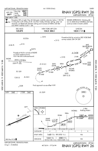
Runways:

RWY identifierQFULength (ft)Width (ft)SurfaceLDA (ft)
08262750ASPH
26262750ASPH

Airport contact information

Address: Mifflintown United States

Satellite view of P34

Sorry, we have no imagery here.

BESbswy
BESbswy