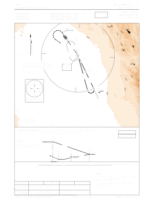
IAC chart of OIMT
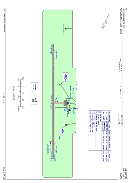
 ADC chart of OIMT
 Satellite view of OIMT
ADC chart of OIMT
Satellite view of OIMT
Sorry, we have no imagery here.
Sorry, we have no imagery here.
Sorry, we have no imagery here.
Sorry, we have no imagery here.
Sorry, we have no imagery here.
Sorry, we have no imagery here.


OIMT - Tabas / National
Located in Tabas, Iran, Islamic Republic of
ICAO - OIMT, IATA - TCX
Data provided by AirmateGeneral information
Coordinates: N33°40'5" E56°53'36"
Elevation is 2251 feet MSL.
View others Airports in Yazd Province
Operational data
Special qualification required
Current time UTC:
Current local time:
Weather
METAR: OIMT 020800Z AUTO 12006KT //// // ////// 32/03 Q1015
Communications frequencies: [VIEW]
Runways:
| RWY identifier | QFU | Length (ft) | Width (ft) | Surface | LDA (ft) |
| 15 | 151° | 9836 | 148 | ASP | |
| 33 | 331° | 9836 | 148 | ASP |
Airport contact information
Address: Tabas Iran, Islamic Republic of
Satellite view of OIMT
Sorry, we have no imagery here.
Sorry, we have no imagery here.
Sorry, we have no imagery here.
Sorry, we have no imagery here.
Sorry, we have no imagery here.
Sorry, we have no imagery here.