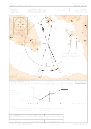
IAC chart of OIKK
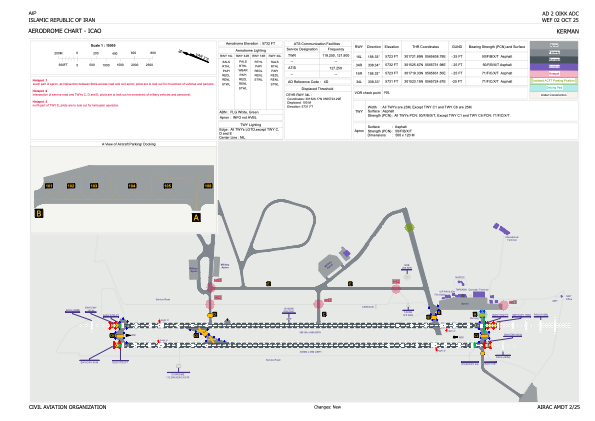
 ADC chart of OIKK
 Satellite view of OIKK
ADC chart of OIKK
Satellite view of OIKK
Sorry, we have no imagery here.
Sorry, we have no imagery here.
Sorry, we have no imagery here.
Sorry, we have no imagery here.
Sorry, we have no imagery here.
Sorry, we have no imagery here.


OIKK - Kerman
Located in Kerman, Iran, Islamic Republic of
ICAO - OIKK, IATA - KER
Data provided by AirmateGeneral information
Coordinates: N30°16'28" E56°57'4"
Elevation is 5732 feet MSL.
View others Airports in Kerman Province
Operational data
Special qualification required
Current time UTC:
Current local time:
Weather
METAR: OIKK 120300Z 13004KT CAVOK 14/05 Q1016 A3001
TAF: TAF OIKK 112310Z 1200/1306 16008KT FEW040 BECMG 1206/1208 20014KT FEW035CB SCT040 BKN100 TEMPO 1209/1215 24014G24KT 5000 SA TS SCT035CB SCT040 BKN090 BECMG 1216/1218 20008KT FEW040
Communications frequencies: [VIEW]
Runways:
| RWY identifier | QFU | Length (ft) | Width (ft) | Surface | LDA (ft) |
| 16L | 158° | 12635 | 148 | UNK | |
| 34R | 338° | 12635 | 148 | UNK | |
| 16R | 158° | 12631 | 148 | UNK | |
| 34L | 338° | 12631 | 148 | UNK |
Airport contact information
Address: Kerman Iran, Islamic Republic of
Satellite view of OIKK
Sorry, we have no imagery here.
Sorry, we have no imagery here.
Sorry, we have no imagery here.
Sorry, we have no imagery here.
Sorry, we have no imagery here.
Sorry, we have no imagery here.