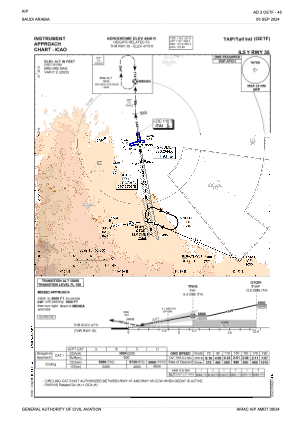
IAC chart of OETF
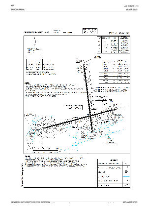
 ADC chart of OETF
 Satellite view of OETF

ADC chart of OETF
Satellite view of OETF
Sorry, we have no imagery here.
Sorry, we have no imagery here.
Sorry, we have no imagery here.
Sorry, we have no imagery here.
Sorry, we have no imagery here.
Sorry, we have no imagery here.


OETF - Taif International Airport
Located in Taif, Saudi Arabia
ICAO - OETF, IATA - TIF
Data provided by AirmateGeneral information
Coordinates: N21°29'0" E40°32'40"
Elevation is 4848 feet MSL.
View others Airports in Makkah
Operational data
Special qualification required
Current time UTC:
Current local time:
Weather
TAF: TAF OETF 261100Z 2612/2718 27012KT 9999 FEW030 PROB30 TEMPO 2612/2618 FEW025CB BECMG 2618/2620 VRB03KT BECMG 2706/2708 14012KT
Communications frequencies: [VIEW]
Runways:
| RWY identifier | QFU | Length (ft) | Width (ft) | Surface | LDA (ft) |
| 17 | 172° | 10991 | 148 | ASP | |
| 35 | 352° | 10991 | 148 | ASP | |
| 07 | 75° | 12254 | 148 | ASP | |
| 25 | 255° | 12254 | 148 | ASP |
Airport contact information
Address: Taif Saudi Arabia
Satellite view of OETF
Sorry, we have no imagery here.
Sorry, we have no imagery here.
Sorry, we have no imagery here.
Sorry, we have no imagery here.
Sorry, we have no imagery here.
Sorry, we have no imagery here.