IAC chart of OESH
 ADC chart of OESH
 Satellite view of OESH

ADC chart of OESH
Satellite view of OESH
Sorry, we have no imagery here.
Sorry, we have no imagery here.
Sorry, we have no imagery here.
Sorry, we have no imagery here.
Sorry, we have no imagery here.
Sorry, we have no imagery here.


OESH - Sharurah
Located in Sharurah, Saudi Arabia
ICAO - OESH, IATA - SHW
Data provided by AirmateGeneral information
Coordinates: N17°28'1" E47°7'17"
Elevation is 2382 feet MSL.
View others Airports in Najran
Operational data
Special qualification required
Current time UTC:
Current local time:
Weather
METAR: OESH 051500Z 17013KT CAVOK 35/M03 Q1010 NOSIG
TAF: TAF OESH 051100Z 0512/0618 17014KT 7000 NSC PROB30 TEMPO 0512/0520 3000 BLDU
Communications frequencies: [VIEW]
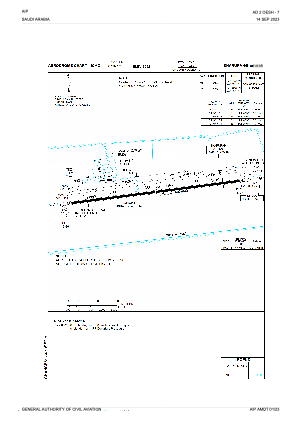
Runways:
| RWY identifier | QFU | Length (ft) | Width (ft) | Surface | LDA (ft) |
| 08 | 85° | 12028 | 148 | ASP | |
| 26 | 265° | 12028 | 148 | ASP |
Airport contact information
Address: Sharurah Saudi Arabia
Satellite view of OESH
Sorry, we have no imagery here.
Sorry, we have no imagery here.
Sorry, we have no imagery here.
Sorry, we have no imagery here.
Sorry, we have no imagery here.
Sorry, we have no imagery here.