VAC chart of OERS
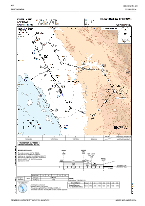
 IAC chart of OERS
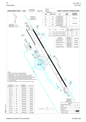
 ADC chart of OERS
 Satellite view of OERS

IAC chart of OERSADC chart of OERS
Satellite view of OERS
Sorry, we have no imagery here.
Sorry, we have no imagery here.
Sorry, we have no imagery here.
Sorry, we have no imagery here.
Sorry, we have no imagery here.
Sorry, we have no imagery here.


OERS - Hanak / Red Sea International
Located in Hanak, Saudi Arabia
ICAO - , IATA - RSI
Data provided by AirmateGeneral information
Coordinates: N25°37'42" E37°5'20"
Elevation is 164 feet MSL.
View others Airports in Tabuk
Operational data
Special qualification required
Current time UTC:
Current local time:
Weather at : - ( 0 km )
METAR: KPWC 250816Z AUTO 00000KT 10SM SCT020 00/M02 A2980 RMK AO2
Communications frequencies: [VIEW]
Runways:
| RWY identifier | QFU | Length (ft) | Width (ft) | Surface | LDA (ft) |
| 15L | 149° | 12139 | 148 | UNK | |
| 33R | 329° | 12139 | 148 | UNK | |
| 15R | 149° | 3297 | 69 | UNK | |
| 33L | 329° | 3297 | 69 | UNK |
Airport contact information
Address: Hanak Saudi Arabia
Satellite view of OERS
Sorry, we have no imagery here.
Sorry, we have no imagery here.
Sorry, we have no imagery here.
Sorry, we have no imagery here.
Sorry, we have no imagery here.
Sorry, we have no imagery here.