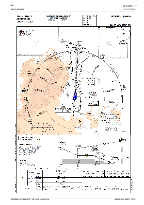
IAC chart of OEHL
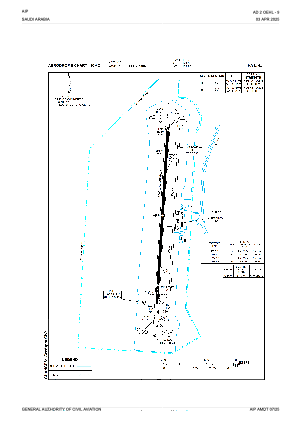
 ADC chart of OEHL
 Satellite view of OEHL
ADC chart of OEHL
Satellite view of OEHL
Sorry, we have no imagery here.
Sorry, we have no imagery here.
Sorry, we have no imagery here.
Sorry, we have no imagery here.
Sorry, we have no imagery here.
Sorry, we have no imagery here.


OEHL - Hail
Located in Hail, Saudi Arabia
ICAO - OEHL, IATA - HAS
Data provided by AirmateGeneral information
Coordinates: N27°26'23" E41°41'11"
Elevation is 3305 feet MSL.
View others Airports in Ha'il
Operational data
Special qualification required
Current time UTC:
Current local time:
Weather
METAR: OEHL 041600Z 15006KT 9999 BKN040 12/08 Q1012
TAF: TAF OEHL 041100Z 0412/0518 16012KT 9999 SCT040 TEMPO 0412/0500 4000 TSRA FEW035CB BKN040 BECMG 0414/0416 04015KT BECMG 0422/0500 26010KT
Communications frequencies: [VIEW]
Runways:
| RWY identifier | QFU | Length (ft) | Width (ft) | Surface | LDA (ft) |
| 18 | 184° | 10827 | 148 | ASP | |
| 36 | 4° | 10827 | 148 | ASP |
Airport contact information
Address: Hail Saudi Arabia
Satellite view of OEHL
Sorry, we have no imagery here.
Sorry, we have no imagery here.
Sorry, we have no imagery here.
Sorry, we have no imagery here.
Sorry, we have no imagery here.
Sorry, we have no imagery here.