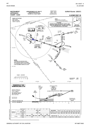
IAC chart of OEGT
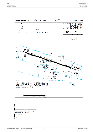
 ADC chart of OEGT
 Satellite view of OEGT

ADC chart of OEGT
Satellite view of OEGT
Sorry, we have no imagery here.
Sorry, we have no imagery here.
Sorry, we have no imagery here.
Sorry, we have no imagery here.
Sorry, we have no imagery here.
Sorry, we have no imagery here.


OEGT - Guriat
Located in Guriat, Saudi Arabia
ICAO - OEGT, IATA - URY
Data provided by AirmateGeneral information
Coordinates: N31°24'43" E37°16'46"
Elevation is 1684 feet MSL.
View others Airports in The Northern Border
Operational data
Special qualification required
Current time UTC:
Current local time:
Weather
METAR: OEGT 250000Z 27004KT CAVOK M01/M07 Q1025 NOSIG
TAF: TAF OEGT 242300Z 2500/2606 VRB03KT CAVOK BECMG 2506/2508 13012KT
Communications frequencies: [VIEW]
Runways:
| RWY identifier | QFU | Length (ft) | Width (ft) | Surface | LDA (ft) |
| 10 | 106° | 10007 | 148 | ASP | |
| 28 | 286° | 10007 | 148 | ASP |
Airport contact information
Address: Guriat Saudi Arabia
Satellite view of OEGT
Sorry, we have no imagery here.
Sorry, we have no imagery here.
Sorry, we have no imagery here.
Sorry, we have no imagery here.
Sorry, we have no imagery here.
Sorry, we have no imagery here.