IAC chart of OEGS
 ADC chart of OEGS
 Satellite view of OEGS

ADC chart of OEGS
Satellite view of OEGS
Sorry, we have no imagery here.
Sorry, we have no imagery here.
Sorry, we have no imagery here.
Sorry, we have no imagery here.
Sorry, we have no imagery here.
Sorry, we have no imagery here.


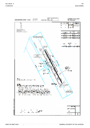
OEGS - Gassim / Prince Naif Bin Abdulaziz
Located in Buraydah, Saudi Arabia
ICAO - OEGS, IATA - ELQ
Data provided by AirmateGeneral information
Coordinates: N26°18'10" E43°46'27"
Elevation is 2126 feet MSL.
View others Airports in Al Qasim
Operational data
Special qualification required
Current time UTC:
Current local time:
Weather
METAR: OEGS 250800Z 08013KT CAVOK 08/M13 Q1028
TAF: TAF OEGS 242300Z 2500/2606 03009KT CAVOK BECMG 2508/2510 08012KT
Communications frequencies: [VIEW]
Runways:
| RWY identifier | QFU | Length (ft) | Width (ft) | Surface | LDA (ft) |
| 15 | 153° | 9843 | 148 | ASP | |
| 33 | 333° | 9843 | 148 | ASP |
Airport contact information
Address: Buraydah Saudi Arabia
Satellite view of OEGS
Sorry, we have no imagery here.
Sorry, we have no imagery here.
Sorry, we have no imagery here.
Sorry, we have no imagery here.
Sorry, we have no imagery here.
Sorry, we have no imagery here.