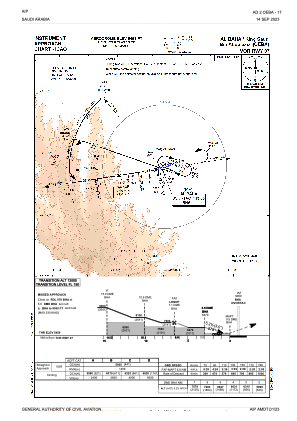
IAC chart of OEBA
 ADC chart of OEBA
 Satellite view of OEBA
ADC chart of OEBA
Satellite view of OEBA
Sorry, we have no imagery here.
Sorry, we have no imagery here.
Sorry, we have no imagery here.
Sorry, we have no imagery here.
Sorry, we have no imagery here.
Sorry, we have no imagery here.


OEBA - Al Baha / King Saud Bin Abdulaziz Airport (Domestic)
Located in Al Baha, Saudi Arabia
ICAO - OEBA, IATA - ABT
Data provided by AirmateGeneral information
Coordinates: N20°17'54" E41°38'9"
Elevation is 5459 feet MSL.
View others Airports in Al Batah
Operational data
Special qualification required
Current time UTC:
Current local time:
Weather
METAR: OEBA 250800Z 08003KT CAVOK 21/03 Q1023 NOSIG
TAF: TAF OEBA 242300Z 2500/2606 17010KT 9999 FEW030 BECMG 2506/2508 24013KT BECMG 2518/2520 VRB03KT
Communications frequencies: [VIEW]
Runways:
| RWY identifier | QFU | Length (ft) | Width (ft) | Surface | LDA (ft) |
| 07 | 71° | 10991 | 148 | ASP | |
| 25 | 251° | 10991 | 148 | ASP |
Airport contact information
Address: Al Baha Saudi Arabia
Satellite view of OEBA
Sorry, we have no imagery here.
Sorry, we have no imagery here.
Sorry, we have no imagery here.
Sorry, we have no imagery here.
Sorry, we have no imagery here.
Sorry, we have no imagery here.