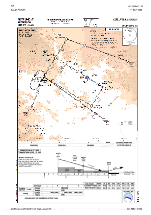
IAC chart of OEAO
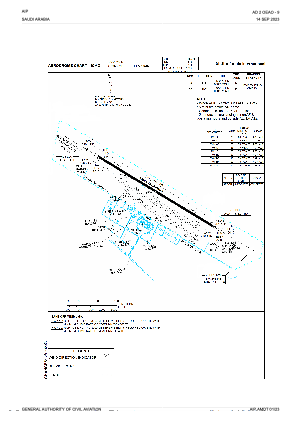
 ADC chart of OEAO
 Satellite view of OEAO
ADC chart of OEAO
Satellite view of OEAO
Sorry, we have no imagery here.
Sorry, we have no imagery here.
Sorry, we have no imagery here.
Sorry, we have no imagery here.
Sorry, we have no imagery here.
Sorry, we have no imagery here.


OEAO - Alula International
Located in Alula, Saudi Arabia
ICAO - , IATA - ULH
Data provided by AirmateGeneral information
Coordinates: N26°28'59" E38°7'7"
Elevation is 2045 feet MSL.
View others Airports in Al Madinah
Operational data
Special qualification required
Current time UTC:
Current local time:
Weather
METAR: OEAO 041600Z 24012KT 9999 SCT040 24/M03 Q1007 NOSIG
Communications frequencies: [VIEW]
Runways:
| RWY identifier | QFU | Length (ft) | Width (ft) | Surface | LDA (ft) |
| 12 | 120° | 10007 | 148 | UNK | |
| 30 | 300° | 10007 | 148 | UNK |
Airport contact information
Address: Alula Saudi Arabia
Satellite view of OEAO
Sorry, we have no imagery here.
Sorry, we have no imagery here.
Sorry, we have no imagery here.
Sorry, we have no imagery here.
Sorry, we have no imagery here.
Sorry, we have no imagery here.