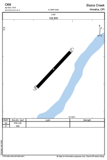
ADC chart of O68
 Satellite view of O68
Satellite view of O68
Sorry, we have no imagery here.
Sorry, we have no imagery here.
Sorry, we have no imagery here.
Sorry, we have no imagery here.
Sorry, we have no imagery here.
Sorry, we have no imagery here.


O68 - Sluice Creek
Located in Imnaha, United States
ICAO - O68, IATA -
Data provided by AirmateGeneral information
Coordinates: N45°26'51" W116°35'6"
Elevation is 1370 feet MSL.
View others Airports in Oregon
Operational data
Special qualification required
Current time UTC:
Current local time:
Weather at : KGIC - Idaho County ( 66 km )
METAR: KGIC 051235Z AUTO 00000KT 7SM CLR M03/M05 A3038 RMK AO1
Communications frequencies: [VIEW]
Runways:
| RWY identifier | QFU | Length (ft) | Width (ft) | Surface | LDA (ft) |
| 03 | 0° | 976 | 25 | GRASS | |
| 21 | 0° | 976 | 25 | GRASS |
Airport contact information
Address: Imnaha United States
Satellite view of O68
Sorry, we have no imagery here.
Sorry, we have no imagery here.
Sorry, we have no imagery here.
Sorry, we have no imagery here.
Sorry, we have no imagery here.
Sorry, we have no imagery here.