IAC chart of O15
 ADC chart of O15
 Satellite view of O15
ADC chart of O15
Satellite view of O15
Sorry, we have no imagery here.
Sorry, we have no imagery here.
Sorry, we have no imagery here.
Sorry, we have no imagery here.
Sorry, we have no imagery here.
Sorry, we have no imagery here.


O15 - Turlock Muni
Located in Turlock, United States
ICAO - O15, IATA -
Data provided by AirmateGeneral information
Coordinates: N37°29'3" W120°41'50"
Elevation is 161 feet MSL.
Magnetic variation is 16° East View others Airports in California
Operational data
Special qualification required
Current time UTC:
Current local time:
Weather at : KMER - Castle ( 16 km )
TAF: KMER 050520Z 0506/0606 VRB05KT P6SM SKC FM051200 VRB05KT P6SM SCT250 FM051800 32004KT P6SM SKC FM060000 35005KT P6SM BKN250 AMD NOT SKED
Communications frequencies: [VIEW]
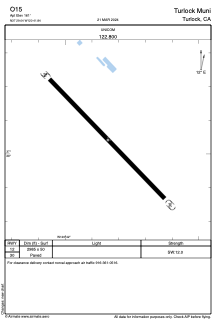
Runways:
| RWY identifier | QFU | Length (ft) | Width (ft) | Surface | LDA (ft) |
| 12 | 0° | 2985 | 50 | ASPH | |
| 30 | 0° | 2985 | 50 | ASPH |
Airport contact information
Address: Turlock United States
Satellite view of O15
Sorry, we have no imagery here.
Sorry, we have no imagery here.
Sorry, we have no imagery here.
Sorry, we have no imagery here.
Sorry, we have no imagery here.
Sorry, we have no imagery here.