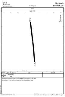
ADC chart of O14
 Satellite view of O14

Satellite view of O14
Sorry, we have no imagery here.
Sorry, we have no imagery here.
Sorry, we have no imagery here.
Sorry, we have no imagery here.
Sorry, we have no imagery here.
Sorry, we have no imagery here.


O14 - Skyroads
Located in Ninnekah, United States
ICAO - O14, IATA -
Data provided by AirmateGeneral information
Coordinates: N34°53'25" W97°59'53"
Elevation is 1200 feet MSL.
View others Airports in Oklahoma
Operational data
Special qualification required
Current time UTC:
Current local time:
Weather at : KCHK - Chickasha Muni ( 23 km )
METAR: KCHK 051215Z AUTO 02021G32KT 10SM -RA OVC011 07/06 A3002 RMK AO2 T00720060
Communications frequencies: [VIEW]
Runways:
| RWY identifier | QFU | Length (ft) | Width (ft) | Surface | LDA (ft) |
| 17 | 0° | 2725 | 60 | GRASS | |
| 35 | 0° | 2725 | 60 | GRASS |
Airport contact information
Address: Ninnekah United States
Satellite view of O14
Sorry, we have no imagery here.
Sorry, we have no imagery here.
Sorry, we have no imagery here.
Sorry, we have no imagery here.
Sorry, we have no imagery here.
Sorry, we have no imagery here.