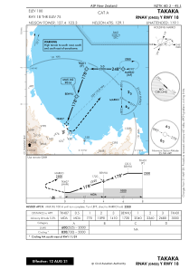
IAC chart of NZTK
 Satellite view of NZTK
Satellite view of NZTK
Sorry, we have no imagery here.
Sorry, we have no imagery here.
Sorry, we have no imagery here.
Sorry, we have no imagery here.
Sorry, we have no imagery here.
Sorry, we have no imagery here.


NZTK - Takaka
Located in Takaka, New Zealand
ICAO - NZTK, IATA - KTF
Data provided by AirmateGeneral information
Coordinates: S40°48'48" E172°46'34"
Elevation is 100 feet MSL.
Magnetic variation is +22° East View others Airports in Tasman Region
Operational data
Special qualification required
Current time UTC:
Current local time:
Weather at : - ( 0 km )
METAR: KI69 112316Z AUTO 02007KT 10SM OVC042 05/00 A3018 RMK AO1 T00531005
Communications frequencies: [VIEW]
Runways:
| RWY identifier | QFU | Length (ft) | Width (ft) | Surface | LDA (ft) |
| 18 | 200° | 2730 | 39 | BITUM | 2631 |
| 36 | 20° | 2730 | 39 | BITUM | 2480 |
| 11 | 134° | 2526 | 39 | GRAVE | 1982 |
| 29 | 314° | 2526 | 39 | GRAVE | 1982 |
Airport contact information
Address: Takaka New Zealand
Satellite view of NZTK
Sorry, we have no imagery here.
Sorry, we have no imagery here.
Sorry, we have no imagery here.
Sorry, we have no imagery here.
Sorry, we have no imagery here.
Sorry, we have no imagery here.