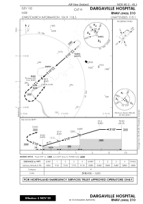
IAC chart of NZJE
 Satellite view of NZJE
Satellite view of NZJE
Sorry, we have no imagery here.
Sorry, we have no imagery here.
Sorry, we have no imagery here.
Sorry, we have no imagery here.
Sorry, we have no imagery here.
Sorry, we have no imagery here.


NZJE - Dargaville Hospital
Located in Dargaville, New Zealand
ICAO - NZJE, IATA -
Data provided by AirmateGeneral information
Coordinates: S35°55'44" E173°52'32"
Elevation is 102 feet MSL.
Magnetic variation is +19° East View others Airports in Northland Region
Operational data
Special qualification required
Current time UTC:
Current local time:
Weather at : - ( 0 km )
METAR: PKWA 111620Z AUTO 08009KT 10SM CLR 27/22 A2984 RMK AO2 T02660224
Communications frequencies: [VIEW]
Runways:
Airport contact information
Address: Dargaville New Zealand
Satellite view of NZJE
Sorry, we have no imagery here.
Sorry, we have no imagery here.
Sorry, we have no imagery here.
Sorry, we have no imagery here.
Sorry, we have no imagery here.
Sorry, we have no imagery here.