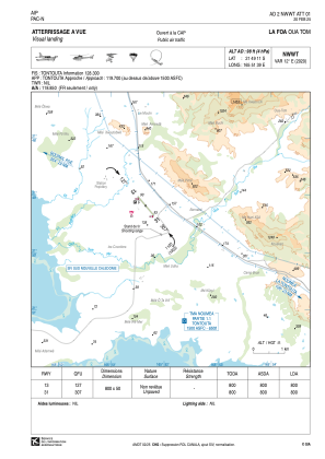
VAC chart of NWWT
 Satellite view of NWWT
Satellite view of NWWT
Sorry, we have no imagery here.
Sorry, we have no imagery here.
Sorry, we have no imagery here.
Sorry, we have no imagery here.
Sorry, we have no imagery here.
Sorry, we have no imagery here.


NWWT - La Foa Oua Tom
Located in La Foa, New Caledonia
ICAO - , IATA -
Data provided by AirmateGeneral information
Coordinates: S21°49'11" E165°51'39"
Elevation is 98 feet MSL.
Magnetic variation is 12.25° East View others Airports in (unassigned)
Operational data
Special qualification required
Current time UTC:
Current local time:
Weather at : NWWW - Noumea La Tontouta ( 42 km )
METAR: NWWW 101900Z AUTO VRB02KT CAVOK 23/22 Q1012 NOSIG
TAF: TAF NWWW 101700Z 1018/1118 00000KT 9999 FEW040 BECMG 1100/1101 14010KT TEMPO 1101/1106 SHRA FEW020TCU PROB40 TEMPO 1103/1106 3000 SHRA BKN014 FEW017CB FM111000 VRB02KT 9999 SCT018 BKN120 BECMG 1116/1118 CAVOK
Communications frequencies: [VIEW]
Runways:
| RWY identifier | QFU | Length (ft) | Width (ft) | Surface | LDA (ft) |
| 13 | 139° | 2625 | 164 | GRASS | 2625 |
| 31 | 319° | 2625 | 164 | GRASS | 2625 |
Airport contact information
Address: La Foa New Caledonia
Satellite view of NWWT
Sorry, we have no imagery here.
Sorry, we have no imagery here.
Sorry, we have no imagery here.
Sorry, we have no imagery here.
Sorry, we have no imagery here.
Sorry, we have no imagery here.