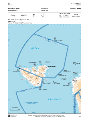
VAC chart of NTTM
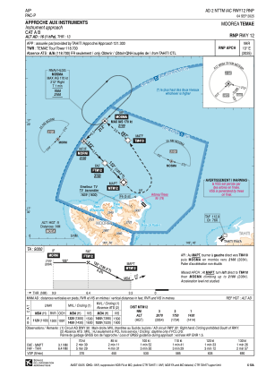
 IAC chart of NTTM
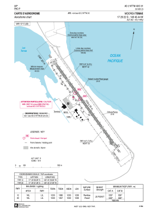
 ADC chart of NTTM
 Satellite view of NTTM
IAC chart of NTTMADC chart of NTTM
Satellite view of NTTM
Sorry, we have no imagery here.
Sorry, we have no imagery here.
Sorry, we have no imagery here.
Sorry, we have no imagery here.
Sorry, we have no imagery here.
Sorry, we have no imagery here.


NTTM - Moorea Temae
Located in Afareaitu, French Polynesia
ICAO - NTTM, IATA - MOZ
Data provided by AirmateGeneral information
Coordinates: S17°29'22" W149°45'44"
Elevation is 16 feet MSL.
Magnetic variation is 12.92° East View others Airports in (unassigned)
Operational data
Special qualification required
Current time UTC:
Current local time:
Weather at : NTAA - Tahiti Faa'a ( 18 km )
METAR: NTAA 101830Z AUTO VRB02KT CAVOK 29/23 Q1014 NOSIG
TAF: TAF NTAA 101700Z 1018/1124 VRB05KT 9999 FEW023 SCT050 PROB30 TEMPO 1100/1104 04015G25KT FEW020TCU TEMPO 1122/1124 04015G25KT
Communications frequencies: [VIEW]
Runways:
| RWY identifier | QFU | Length (ft) | Width (ft) | Surface | LDA (ft) |
| 12 | 135° | 4035 | 98 | BITUM | 4035 |
| 30 | 315° | 4035 | 98 | BITUM | 4035 |
Airport contact information
Address: Afareaitu French Polynesia
Satellite view of NTTM
Sorry, we have no imagery here.
Sorry, we have no imagery here.
Sorry, we have no imagery here.
Sorry, we have no imagery here.
Sorry, we have no imagery here.
Sorry, we have no imagery here.