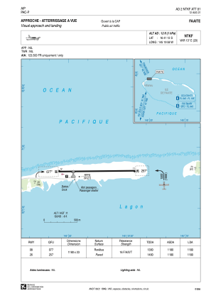
VAC chart of NTKF
 Satellite view of NTKF
Satellite view of NTKF
Sorry, we have no imagery here.
Sorry, we have no imagery here.
Sorry, we have no imagery here.
Sorry, we have no imagery here.
Sorry, we have no imagery here.
Sorry, we have no imagery here.


NTKF - Faaite
Located in Hitianau, French Polynesia
ICAO - NTKF, IATA - FAC
Data provided by AirmateGeneral information
Coordinates: S16°41'12" W145°19'58"
Elevation is 12 feet MSL.
Magnetic variation is 12.67° East View others Airports in (unassigned)
Operational data
Special qualification required
Current time UTC:
Current local time:
Weather at : - ( 0 km )
METAR: ULLI 111231Z 34009MPS 9999 -SHRASN SCT010 BKN019CB 01/M01 Q0995 R28L/290042 R28R/290045 NOSIG
Communications frequencies: [VIEW]
Runways:
| RWY identifier | QFU | Length (ft) | Width (ft) | Surface | LDA (ft) |
| 08 | 89° | 3871 | 75 | ASPH | 3871 |
| 26 | 269° | 3871 | 75 | ASPH | 3871 |
Airport contact information
Address: Hitianau French Polynesia
Satellite view of NTKF
Sorry, we have no imagery here.
Sorry, we have no imagery here.
Sorry, we have no imagery here.
Sorry, we have no imagery here.
Sorry, we have no imagery here.
Sorry, we have no imagery here.