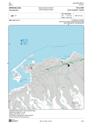
VAC chart of NTHP
 Satellite view of NTHP
Satellite view of NTHP
Sorry, we have no imagery here.
Sorry, we have no imagery here.
Sorry, we have no imagery here.
Sorry, we have no imagery here.
Sorry, we have no imagery here.


NTHP - Pirae Chpf
Located in , French Polynesia
ICAO - , IATA -
Data provided by AirmateGeneral information
Coordinates: S17°31'41" W149°32'47"
Elevation is 96 feet MSL.
Magnetic variation is 12.94° East View others Airports in (unassigned)
Operational data
Special qualification required
Current time UTC:
Current local time:
Weather at : NTAA - Tahiti Faa'a ( 8 km )
METAR: NTAA 100700Z AUTO 08004KT CAVOK 27/20 Q1014 NOSIG
TAF: TAF NTAA 100500Z 1006/1112 VRB05KT 9999 FEW023 SCT050 BECMG 1022/1023 04020G30KT BECMG 1103/1104 VRB03KT
Communications frequencies: [VIEW]
Runways:
Airport contact information
Address: French Polynesia
Satellite view of NTHP
Sorry, we have no imagery here.
Sorry, we have no imagery here.
Sorry, we have no imagery here.
Sorry, we have no imagery here.
Sorry, we have no imagery here.