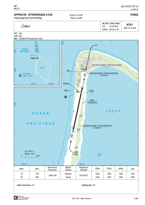
VAC chart of NTGY
 IAC chart of NTGY
 ADC chart of NTGY
 Satellite view of NTGY
IAC chart of NTGYADC chart of NTGY
Satellite view of NTGY
Sorry, we have no imagery here.
Sorry, we have no imagery here.
Sorry, we have no imagery here.
Sorry, we have no imagery here.
Sorry, we have no imagery here.
Sorry, we have no imagery here.


NTGY - Tureia
Located in Fakamaru, French Polynesia
ICAO - NTGY, IATA - ZTA
Data provided by AirmateGeneral information
Coordinates: S20°46'48" W138°34'1"
Elevation is 10 feet MSL.
Magnetic variation is 13.78° East View others Airports in (unassigned)
Operational data
Special qualification required
Current time UTC:
Current local time:
Weather at : - ( 0 km )
METAR: UIBB 111301Z 17004MPS 120V200 0900 R30/P2000N +SHSN VV005 M04/M05 Q1020 R30/490232 NOSIG RMK QBB150 MT OBSC QFE721/0962
Communications frequencies: [VIEW]
Runways:
| RWY identifier | QFU | Length (ft) | Width (ft) | Surface | LDA (ft) |
| 18 | 192° | 4265 | 98 | ASPH | 3675 |
| 36 | 12° | 4265 | 98 | ASPH | 4265 |
Airport contact information
Address: Fakamaru French Polynesia
Satellite view of NTGY
Sorry, we have no imagery here.
Sorry, we have no imagery here.
Sorry, we have no imagery here.
Sorry, we have no imagery here.
Sorry, we have no imagery here.
Sorry, we have no imagery here.