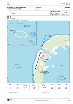
VAC chart of NTGV
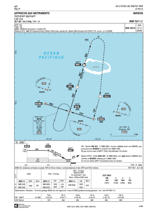
 IAC chart of NTGV
 Satellite view of NTGV
IAC chart of NTGV
Satellite view of NTGV
Sorry, we have no imagery here.
Sorry, we have no imagery here.
Sorry, we have no imagery here.
Sorry, we have no imagery here.
Sorry, we have no imagery here.
Sorry, we have no imagery here.


NTGV - Mataiva
Located in Pahua, French Polynesia
ICAO - NTGV, IATA - MVT
Data provided by AirmateGeneral information
Coordinates: S14°52'10" W148°42'46"
Elevation is 18 feet MSL.
Magnetic variation is 12.16° East View others Airports in (unassigned)
Operational data
Special qualification required
Current time UTC:
Current local time:
Weather at : - ( 0 km )
METAR: YPCC 111020Z AUTO 15011KT 9999 -SHRA SCT017 BKN022 BKN032 28/27 Q1009 RESHRA
Communications frequencies: [VIEW]
Runways:
| RWY identifier | QFU | Length (ft) | Width (ft) | Surface | LDA (ft) |
| 01 | 17° | 3937 | 98 | ASPH | 3937 |
| 19 | 197° | 3937 | 98 | ASPH | 3937 |
Airport contact information
Address: Pahua French Polynesia
Satellite view of NTGV
Sorry, we have no imagery here.
Sorry, we have no imagery here.
Sorry, we have no imagery here.
Sorry, we have no imagery here.
Sorry, we have no imagery here.
Sorry, we have no imagery here.