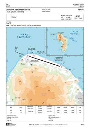
VAC chart of NTAR
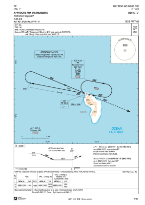
 IAC chart of NTAR
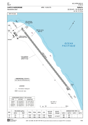
 ADC chart of NTAR
 Satellite view of NTAR
IAC chart of NTARADC chart of NTAR
Satellite view of NTAR
Sorry, we have no imagery here.
Sorry, we have no imagery here.
Sorry, we have no imagery here.
Sorry, we have no imagery here.
Sorry, we have no imagery here.
Sorry, we have no imagery here.


NTAR - Rurutu
Located in Moerai, French Polynesia
ICAO - NTAR, IATA - RUR
Data provided by AirmateGeneral information
Coordinates: S22°25'54" W151°22'2"
Elevation is 27 feet MSL.
Magnetic variation is 14.57° East View others Airports in (unassigned)
Operational data
Special qualification required
Current time UTC:
Current local time:
Communications frequencies: [VIEW]
Runways:
| RWY identifier | QFU | Length (ft) | Width (ft) | Surface | LDA (ft) |
| 09 | 108° | 4757 | 98 | ASPH | 4708 |
| 27 | 288° | 4757 | 98 | ASPH | 4724 |
Airport contact information
Address: Moerai French Polynesia
Satellite view of NTAR
Sorry, we have no imagery here.
Sorry, we have no imagery here.
Sorry, we have no imagery here.
Sorry, we have no imagery here.
Sorry, we have no imagery here.
Sorry, we have no imagery here.