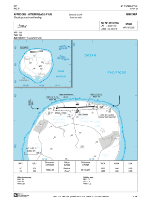
VAC chart of NTAM
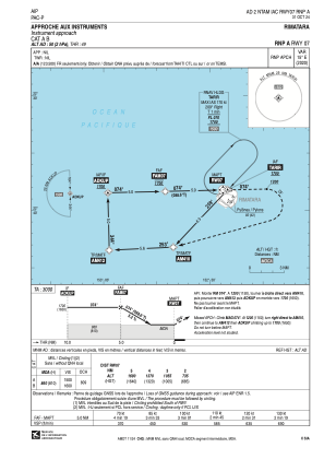
 IAC chart of NTAM
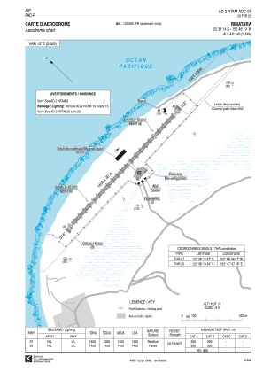
 ADC chart of NTAM
 Satellite view of NTAM
IAC chart of NTAMADC chart of NTAM
Satellite view of NTAM
Sorry, we have no imagery here.
Sorry, we have no imagery here.
Sorry, we have no imagery here.
Sorry, we have no imagery here.
Sorry, we have no imagery here.
Sorry, we have no imagery here.


NTAM - Rimatara
Located in , French Polynesia
ICAO - NTAM, IATA - RMT
Data provided by AirmateGeneral information
Coordinates: S22°38'14" W152°48'19"
Elevation is 50 feet MSL.
Magnetic variation is 14.64° East View others Airports in (unassigned)
Operational data
Special qualification required
Current time UTC:
Current local time:
Weather at : - ( 0 km )
METAR: URWI 100626Z 15002MPS 2500 1400E BR OVC002 01/00 Q1012 R09/290050 NOSIG RMK QBB070 OBST OBSC
Communications frequencies: [VIEW]
Runways:
| RWY identifier | QFU | Length (ft) | Width (ft) | Surface | LDA (ft) |
| 07 | 89° | 4593 | 98 | ASPH | 4593 |
| 25 | 269° | 4593 | 98 | ASPH | 4593 |
Airport contact information
Address: French Polynesia
Satellite view of NTAM
Sorry, we have no imagery here.
Sorry, we have no imagery here.
Sorry, we have no imagery here.
Sorry, we have no imagery here.
Sorry, we have no imagery here.
Sorry, we have no imagery here.