ADC chart of NR32
 Satellite view of NR32
Satellite view of NR32
Sorry, we have no imagery here.
Sorry, we have no imagery here.
Sorry, we have no imagery here.
Sorry, we have no imagery here.
Sorry, we have no imagery here.
Sorry, we have no imagery here.


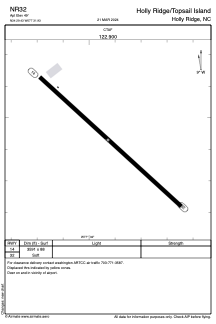
NR32 - Holly Ridge/Topsail Island
Located in Holly Ridge, United States
ICAO - NR32, IATA -
Data provided by AirmateGeneral information
Coordinates: N34°29'26" W77°31'56"
Elevation is 49 feet MSL.
Magnetic variation is -08° East View others Airports in North Carolina
Operational data
Special qualification required
Current time UTC:
Current local time:
Weather at : KNCA - New River Mcas (Mccutcheon Fld) ( 26 km )
TAF: TAF KNCA 0121/0221 36008KT 9999 SCT055 QNH3001INS FM020100 09008KT 9999 BKN030 QNH3015INS BECMG 0214/0216 10010G20KT 9999 QNH3027INS TX21/0219Z TN11/0211Z
Communications frequencies: [VIEW]
Runways:
| RWY identifier | QFU | Length (ft) | Width (ft) | Surface | LDA (ft) |
| 14 | 132° | 3591 | 88 | GRASS | |
| 32 | 312° | 3591 | 88 | GRASS |
Airport contact information
Address: Holly Ridge United States
Satellite view of NR32
Sorry, we have no imagery here.
Sorry, we have no imagery here.
Sorry, we have no imagery here.
Sorry, we have no imagery here.
Sorry, we have no imagery here.
Sorry, we have no imagery here.