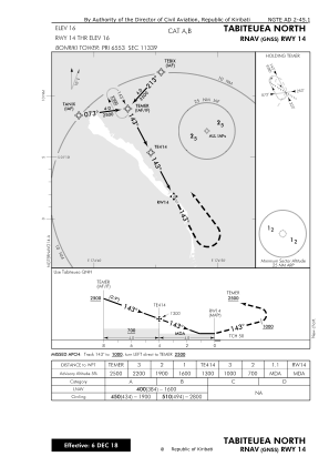
IAC chart of NGTE
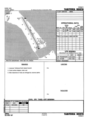
 ADC chart of NGTE
 Satellite view of NGTE
ADC chart of NGTE
Satellite view of NGTE
Sorry, we have no imagery here.
Sorry, we have no imagery here.
Sorry, we have no imagery here.
Sorry, we have no imagery here.
Sorry, we have no imagery here.
Sorry, we have no imagery here.


NGTE - Tabiteuea North
Located in , Kiribati
ICAO - NGTE, IATA - TBF
Data provided by AirmateGeneral information
Coordinates: S1°13'25" E174°46'33"
Elevation is 16 feet MSL.
Magnetic variation is 10° East View others Airports in Gilbert Islands
Operational data
Special qualification required
Current time UTC:
Current local time:
Weather at : - ( 0 km )
METAR: UHWW 112035Z 25002MPS 0350 0050W R25L/1600D FG VV002 00/00 Q1013 R25L/0///70 NOSIG RMK QBB060 MT OBSC QFE759
Communications frequencies: [VIEW]
Runways:
| RWY identifier | QFU | Length (ft) | Width (ft) | Surface | LDA (ft) |
| 14 | 153° | 3399 | 98 | COR | |
| 32 | 333° | 3399 | 98 | COR |
Airport contact information
Address: Kiribati
Satellite view of NGTE
Sorry, we have no imagery here.
Sorry, we have no imagery here.
Sorry, we have no imagery here.
Sorry, we have no imagery here.
Sorry, we have no imagery here.
Sorry, we have no imagery here.