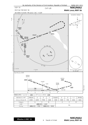
IAC chart of NGNU
 Satellite view of NGNU
Satellite view of NGNU
Sorry, we have no imagery here.
Sorry, we have no imagery here.
Sorry, we have no imagery here.
Sorry, we have no imagery here.
Sorry, we have no imagery here.
Sorry, we have no imagery here.


NGNU - Nikunau Airport
Located in Nikunau, Kiribati
ICAO - NGNU, IATA - NIG
Data provided by AirmateGeneral information
Coordinates: S1°18'57" E176°24'23"
Elevation is 18 feet MSL.
Magnetic variation is 10° East View others Airports in Gilbert Islands
Operational data
Special qualification required
Current time UTC:
Current local time:
Weather at : - ( 0 km )
METAR: PTKK 101554Z 06007KT 15SM FEW014 SCT120 BKN280 28/25 A2977 RMK SLP084 T02810247
Communications frequencies: [VIEW]
Runways:
| RWY identifier | QFU | Length (ft) | Width (ft) | Surface | LDA (ft) |
| 06 | 0° | 3403 | 118 | UNK | |
| 24 | 0° | 3403 | 118 | UNK |
Airport contact information
Address: Nikunau Kiribati
Satellite view of NGNU
Sorry, we have no imagery here.
Sorry, we have no imagery here.
Sorry, we have no imagery here.
Sorry, we have no imagery here.
Sorry, we have no imagery here.
Sorry, we have no imagery here.