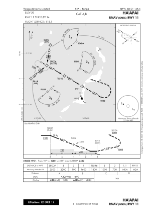
IAC chart of NFTL
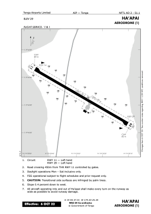
 ADC chart of NFTL
 Satellite view of NFTL
ADC chart of NFTL
Satellite view of NFTL
Sorry, we have no imagery here.
Sorry, we have no imagery here.
Sorry, we have no imagery here.
Sorry, we have no imagery here.
Sorry, we have no imagery here.
Sorry, we have no imagery here.


NFTL - Haapai
Located in Pangai, Tonga
ICAO - NFTL, IATA - HPA
Data provided by AirmateGeneral information
Coordinates: S19°46'37" W174°20'25"
Elevation is 29 feet MSL.
View others Airports in Ha'apai
Operational data
Special qualification required
Current time UTC:
Current local time:
Weather
METAR: NFTL 100400Z 10010KT 9999 FEW010 SCT016 BKN110 28/26 Q1012
Communications frequencies: [VIEW]
Runways:
| RWY identifier | QFU | Length (ft) | Width (ft) | Surface | LDA (ft) |
| 11 | 0° | 3937 | 98 | BITUM | |
| 29 | 0° | 3937 | 98 | BITUM |
Airport contact information
Address: Pangai Tonga
Satellite view of NFTL
Sorry, we have no imagery here.
Sorry, we have no imagery here.
Sorry, we have no imagery here.
Sorry, we have no imagery here.
Sorry, we have no imagery here.
Sorry, we have no imagery here.