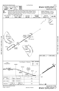
IAC chart of N96
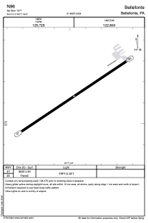
 ADC chart of N96
 Satellite view of N96
ADC chart of N96
Satellite view of N96
Sorry, we have no imagery here.
Sorry, we have no imagery here.
Sorry, we have no imagery here.
Sorry, we have no imagery here.
Sorry, we have no imagery here.
Sorry, we have no imagery here.


N96 - Bellefonte
Located in Bellefonte, United States
ICAO - N96, IATA -
Data provided by AirmateGeneral information
Coordinates: N40°53'8" W77°48'58"
Elevation is 1072 feet MSL.
Magnetic variation is -10° East View others Airports in Pennsylvania
Operational data
Special qualification required
Current time UTC:
Current local time:
Weather at : KUNV - State College Rgnl ( 5 km )
METAR: KUNV 081253Z 32010G16KT 6SM -SN SCT020 BKN030 OVC038 M03/M07 A2983
TAF: KUNV 081143Z 0812/0912 30012G20KT 3/4SM -SHSN OVC015 FM081300 30021G30KT P6SM SCT025 BKN050 FM082000 30018G26KT P6SM SKC FM090300 29008KT P6SM SKC FM090900 26004KT P6SM SKC
Communications frequencies: [VIEW]
Runways:
| RWY identifier | QFU | Length (ft) | Width (ft) | Surface | LDA (ft) |
| 07 | 56° | 3632 | 60 | ASPH | |
| 25 | 236° | 3632 | 60 | ASPH |
Airport contact information
Address: Bellefonte United States
Other aviation service providers
Flight schools

Satellite view of N96
Sorry, we have no imagery here.
Sorry, we have no imagery here.
Sorry, we have no imagery here.
Sorry, we have no imagery here.
Sorry, we have no imagery here.
Sorry, we have no imagery here.