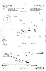
IAC chart of N94
 ADC chart of N94
 Satellite view of N94
ADC chart of N94
Satellite view of N94
Sorry, we have no imagery here.
Sorry, we have no imagery here.
Sorry, we have no imagery here.
Sorry, we have no imagery here.
Sorry, we have no imagery here.
Sorry, we have no imagery here.


N94 - Carlisle
Located in Carlisle, United States
ICAO - N94, IATA -
Data provided by AirmateGeneral information
Coordinates: N40°11'16" W77°10'27"
Elevation is 510 feet MSL.
Magnetic variation is -10° East View others Airports in Pennsylvania
Operational data
Special qualification required
Current time UTC:
Current local time:
Weather at : KCXY - Capital City ( 28 km )
METAR: KCXY 081556Z 30017G32KT 10SM SCT055 06/M09 A2986 RMK AO2 PK WND 28032/1549 RAB14E41SNB1459E09 SLP116 P0000 T00561094
Communications frequencies: [VIEW]
Runways:
| RWY identifier | QFU | Length (ft) | Width (ft) | Surface | LDA (ft) |
| 10 | 92° | 4008 | 60 | ASPH | |
| 28 | 272° | 4008 | 60 | ASPH |
Airport contact information
Address: Carlisle United States
Other aviation service providers
Flight schools

Satellite view of N94
Sorry, we have no imagery here.
Sorry, we have no imagery here.
Sorry, we have no imagery here.
Sorry, we have no imagery here.
Sorry, we have no imagery here.
Sorry, we have no imagery here.