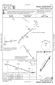
IAC chart of N89
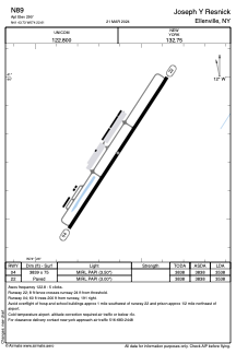
 ADC chart of N89
 Satellite view of N89
ADC chart of N89
Satellite view of N89
Sorry, we have no imagery here.
Sorry, we have no imagery here.
Sorry, we have no imagery here.
Sorry, we have no imagery here.
Sorry, we have no imagery here.


N89 - Joseph Y Resnick
Located in Ellenville, United States
ICAO - N89, IATA -
Data provided by AirmateGeneral information
Coordinates: N41°43'44" W74°22'37"
Elevation is 290 feet MSL.
Magnetic variation is -14° East View others Airports in New York
Operational data
Special qualification required
Current time UTC:
Current local time:
Weather at : KMGJ - Orange County ( 26 km )
METAR: KMGJ 080334Z AUTO 00000KT 10SM OVC013 03/02 A2962 RMK AO2 RAE06 P0000 T00330022
Communications frequencies: [VIEW]
Runways:
| RWY identifier | QFU | Length (ft) | Width (ft) | Surface | LDA (ft) |
| 04 | 33° | 3839 | 75 | ASPH | 3538 |
| 22 | 213° | 3839 | 75 | ASPH | 3538 |
Airport contact information
Address: Ellenville United States
Satellite view of N89
Sorry, we have no imagery here.
Sorry, we have no imagery here.
Sorry, we have no imagery here.
Sorry, we have no imagery here.
Sorry, we have no imagery here.