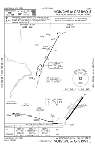
IAC chart of N82
 Satellite view of N82
Satellite view of N82
Sorry, we have no imagery here.
Sorry, we have no imagery here.
Sorry, we have no imagery here.
Sorry, we have no imagery here.
Sorry, we have no imagery here.
Sorry, we have no imagery here.


N82 - Wurtsboro/Sullivan County
Located in Wurtsboro, United States
ICAO - N82, IATA -
Data provided by AirmateGeneral information
Coordinates: N41°35'52" W74°27'33"
Elevation is 548 feet MSL.
Magnetic variation is -12° East View others Airports in New York
Operational data
Special qualification required
Current time UTC:
Current local time:
Weather at : KMGJ - Orange County ( 19 km )
METAR: KMGJ 081254Z AUTO 29011G24KT 250V320 10SM FEW043 01/M08 A2967 RMK AO2 PK WND 30026/1233 SLP050 T00111078
Communications frequencies: [VIEW]
Runways:
| RWY identifier | QFU | Length (ft) | Width (ft) | Surface | LDA (ft) |
| 05 | 36° | 3591 | 60 | ASPH | |
| 23 | 216° | 3591 | 60 | ASPH | |
| 09 | 78° | 1101 | 110 | GRASS | |
| 27 | 258° | 1101 | 110 | GRASS |
Airport contact information
Address: Wurtsboro United States
Other aviation service providers
Flight schools

Satellite view of N82
Sorry, we have no imagery here.
Sorry, we have no imagery here.
Sorry, we have no imagery here.
Sorry, we have no imagery here.
Sorry, we have no imagery here.
Sorry, we have no imagery here.