ADC chart of N74
 Satellite view of N74
Satellite view of N74
Sorry, we have no imagery here.
Sorry, we have no imagery here.
Sorry, we have no imagery here.
Sorry, we have no imagery here.
Sorry, we have no imagery here.
Sorry, we have no imagery here.


N74 - Penns Cave
Located in Centre Hall, United States
ICAO - N74, IATA -
Data provided by AirmateGeneral information
Coordinates: N40°53'24" W77°36'11"
Elevation is 1245 feet MSL.
Magnetic variation is -10° East View others Airports in Pennsylvania
Operational data
Special qualification required
Current time UTC:
Current local time:
Weather at : KUNV - State College Rgnl ( 21 km )
METAR: KUNV 111153Z 00000KT 10SM CLR 16/14 A3027
TAF: KUNV 111121Z 1112/1212 19004KT P6SM SKC FM121000 00000KT 6SM BR SKC
Communications frequencies: [VIEW]
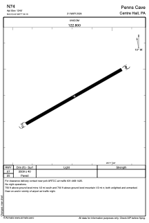
Runways:
| RWY identifier | QFU | Length (ft) | Width (ft) | Surface | LDA (ft) |
| 07 | 0° | 2509 | 40 | ASPH | |
| 25 | 0° | 2509 | 40 | ASPH |
Airport contact information
Address: Centre Hall United States
Satellite view of N74
Sorry, we have no imagery here.
Sorry, we have no imagery here.
Sorry, we have no imagery here.
Sorry, we have no imagery here.
Sorry, we have no imagery here.
Sorry, we have no imagery here.