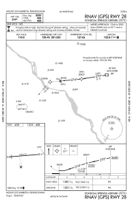
IAC chart of N71
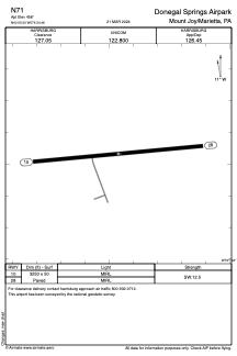
 ADC chart of N71
 Satellite view of N71
ADC chart of N71
Satellite view of N71
Sorry, we have no imagery here.
Sorry, we have no imagery here.
Sorry, we have no imagery here.
Sorry, we have no imagery here.
Sorry, we have no imagery here.


N71 - Donegal Springs Airpark
Located in Mount Joy/Marietta, United States
ICAO - N71, IATA -
Data provided by AirmateGeneral information
Coordinates: N40°5'32" W76°34'28"
Elevation is 458 feet MSL.
Magnetic variation is -09° East View others Airports in Pennsylvania
Operational data
Special qualification required
Current time UTC:
Current local time:
Weather at : KMDT - Harrisburg Intl ( 20 km )
METAR: KMDT 080256Z VRB03KT 10SM SCT020 BKN180 06/03 A2965 RMK AO2 SLP043 T00610033 58009
TAF: KMDT 080152Z 0802/0824 26007KT P6SM SCT015 BKN025 FM080500 30015G25KT P6SM BKN035 FM080900 31020G30KT P6SM SCT100 FM081300 30025G34KT P6SM SCT070
Communications frequencies: [VIEW]
Runways:
| RWY identifier | QFU | Length (ft) | Width (ft) | Surface | LDA (ft) |
| 10 | 85° | 3250 | 50 | ASPH | |
| 28 | 265° | 3250 | 50 | ASPH |
Airport contact information
Address: Mount Joy/Marietta United States
Satellite view of N71
Sorry, we have no imagery here.
Sorry, we have no imagery here.
Sorry, we have no imagery here.
Sorry, we have no imagery here.
Sorry, we have no imagery here.