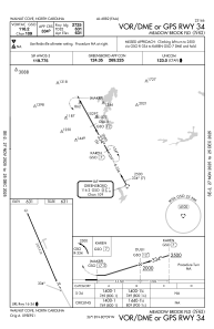
IAC chart of N63
 Satellite view of N63
Satellite view of N63
Sorry, we have no imagery here.
Sorry, we have no imagery here.
Sorry, we have no imagery here.
Sorry, we have no imagery here.
Sorry, we have no imagery here.
Sorry, we have no imagery here.


N63 - Meadow Brook Fld
Located in Walnut Cove, United States
ICAO - N63, IATA -
Data provided by AirmateGeneral information
Coordinates: N36°18'5" W80°8'54"
Elevation is 631 feet MSL.
Magnetic variation is -06° East View others Airports in North Carolina
Operational data
Special qualification required
Current time UTC:
Current local time:
Weather at : KINT - Smith Reynolds ( 20 km )
METAR: KINT 020054Z 09004KT 10SM CLR 16/02 A3013 RMK AO2 SLP200 T01560022
TAF: KINT 012334Z 0200/0224 08004KT P6SM SCT250 FM020800 08005KT P6SM BKN007 FM021200 09005KT P6SM OVC007 FM021800 10006KT P6SM BKN007
Communications frequencies: [VIEW]
Runways:
| RWY identifier | QFU | Length (ft) | Width (ft) | Surface | LDA (ft) |
| 16 | 160° | 2725 | 32 | ASPH | |
| 34 | 340° | 2725 | 32 | ASPH |
Airport contact information
Address: Walnut Cove United States
Satellite view of N63
Sorry, we have no imagery here.
Sorry, we have no imagery here.
Sorry, we have no imagery here.
Sorry, we have no imagery here.
Sorry, we have no imagery here.
Sorry, we have no imagery here.