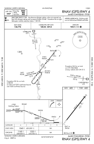
IAC chart of N52
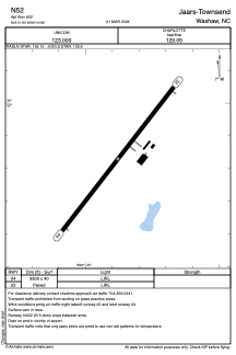
 ADC chart of N52
 Satellite view of N52
ADC chart of N52
Satellite view of N52
Sorry, we have no imagery here.
Sorry, we have no imagery here.
Sorry, we have no imagery here.
Sorry, we have no imagery here.
Sorry, we have no imagery here.
Sorry, we have no imagery here.


N52 - Jaars-Townsend
Located in Waxhaw, United States
ICAO - N52, IATA -
Data provided by AirmateGeneral information
Coordinates: N34°51'50" W80°44'53"
Elevation is 602 feet MSL.
Magnetic variation is -07° East View others Airports in North Carolina
Operational data
Special qualification required
Current time UTC:
Current local time:
Weather at : KLKR - Lancaster County-Mc Whirter Fld ( 18 km )
METAR: KLKR 020355Z AUTO 00000KT 10SM CLR 14/10 A3013 RMK AO2
Communications frequencies: [VIEW]
Runways:
| RWY identifier | QFU | Length (ft) | Width (ft) | Surface | LDA (ft) |
| 04 | 38° | 3309 | 40 | ASPH | |
| 22 | 218° | 3309 | 40 | ASPH |
Airport contact information
Address: Waxhaw United States
Satellite view of N52
Sorry, we have no imagery here.
Sorry, we have no imagery here.
Sorry, we have no imagery here.
Sorry, we have no imagery here.
Sorry, we have no imagery here.
Sorry, we have no imagery here.