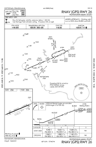
IAC chart of N47
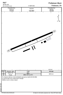
 ADC chart of N47
 Satellite view of N47
ADC chart of N47
Satellite view of N47
Sorry, we have no imagery here.
Sorry, we have no imagery here.
Sorry, we have no imagery here.
Sorry, we have no imagery here.
Sorry, we have no imagery here.
Sorry, we have no imagery here.


N47 - Pottstown Muni
Located in Pottstown, United States
ICAO - N47, IATA -
Data provided by AirmateGeneral information
Coordinates: N40°15'38" W75°40'15"
Elevation is 256 feet MSL.
Magnetic variation is -12° East View others Airports in Pennsylvania
Operational data
Special qualification required
Current time UTC:
Current local time:
Weather at : KPTW - Heritage Fld ( 10 km )
METAR: KPTW 081254Z AUTO 29010G25KT 10SM CLR 02/M08 A2981 RMK AO2 PK WND 31029/1233 SLP093 T00171078
Communications frequencies: [VIEW]
Runways:
| RWY identifier | QFU | Length (ft) | Width (ft) | Surface | LDA (ft) |
| 08 | 67° | 2704 | 75 | ASPH | |
| 26 | 247° | 2704 | 75 | ASPH |
Airport contact information
Address: Pottstown United States
Other aviation service providers
Flight schools

Satellite view of N47
Sorry, we have no imagery here.
Sorry, we have no imagery here.
Sorry, we have no imagery here.
Sorry, we have no imagery here.
Sorry, we have no imagery here.
Sorry, we have no imagery here.